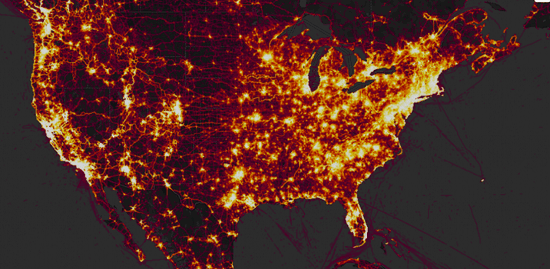
GPS tracking company Strava recently posted an online interactive map online that shows the location and activity patterns of the company’s users, but has also led to a report by the U.S. Department of Defense on sensitive areas Concerns about the security of soldiers and other military bases.
According to The Washington Post, the global hotspot released by Strava uses satellite information to map the locations and activities of consumers who ordered the company’s health devices for two years and light up their area of activity. Strava claims to have 27 million users worldwide, including a community of users who own health devices and place mobile apps directly.

Although this map is not real-time, it shows the user’s cumulative activity from 2015 to September 2017. This map shows a large number of active users in the United States and Europe, but in many theater and desert areas of the country, such as Iraq and Syria, the heat map is almost completely black except for some scattered traces of activity.
https://twitter.com/N_Waters89/status/957323495226167296
As you zoom in on those areas, you will find locations and outlines of known U.S. bases and other potentially sensitive locations unknown, most likely due to the health tracking devices being used by US soldiers and others in their missions. This global hot map was released online in November 2017, but the content it contains was only recently released. The Washington Post reported that the data could provide useful information to some who want to ambush the military. Military officials are discussing the situation to decide how to respond.
A spokesman for the Department of Defense, Major Audricia Harris told: “The Department of Defence (DoD) takes matters like these very seriously and is reviewing the situation to determine if any additional training or guidance is required and if any additional policy must be developed to ensure the continued safety of DoD personnel at home and abroad.”